


Before people get the wrong idea about where I fit in the Earth Science spectrum, I should emphasise that I’m not an oceanographer – I’m a geologist. I just happen to work at the National Oceanography Centre in Southampton (NOCS, an acronym which still sounds faintly dodgy to me, although I can’t really pinpoint why). Another name would be 'The Institute formerly known as Southampton Oceanography Centre' (a long story, but basically our new Director thought it was a good idea). Harry Bryden also works here, which is one of the reasons that I’ve been inspired to write not one, but two, posts about the recent excitement over the thermohaline circulation. Not that I’m pretending that working in the same building gives me any particular insight into the research: in fact, the only meaningful conversation I’ve ever had with Harry was a couple of weeks ago, when we discussed microwave methods for jacket potatoes (he was waiting for me to finish heating my lunch in one of the canteen areas).
NOCS is jointly run by the University of Southampton (the School of Ocean and Earth Science is located in the building) and the National Environment Research Council (NERC), one of the UK government’s research bodies. By ‘jointly run’, I mean that we have both University and NERC staff in the building; I don’t mean to imply that they actually talk to each other or anything like that.
Courtesy of Google Earth, which I’ve been having a lot of fun with recently, lets have a look at the Oceanography Centre:
Southampton is on the south coast of England (if you're still lost, look here). You can find NOCS in the middle of Southampton Docks. The two rivers at the top, the Test (to the east) and the Itchen (to the west), combine into Southampton Water, which opens out into the Solent (the channel separating us from the Isle of Wight) off the bottom of the image.
Here's the NOCS building itself. Believe me, it's not any prettier at ground level. I've marked where my office is. It is from here I work, in the words of one of my colleagues, as a ‘skivvy for a higher power'.
I'd like to draw your attention to two features on this image. The first is that NOCS is located right on the dockside, which is, you are probably thinking, an ideal location for an oceanography research centre; research vessels can park right alongside between cruises, allowing scientific equipment to be easily transferred to and from the ship. Unfortunately, the lack of any such ships in the image isn't just an accident of when the satellite went over. When the building was commissioned no-one thought to negotiate with the port authority about berthing fees, so they charge our ships commercial rates - these are so high that it's actually cheaper to park the ships somewhere else and transfer everything by truck. Places like Hull. 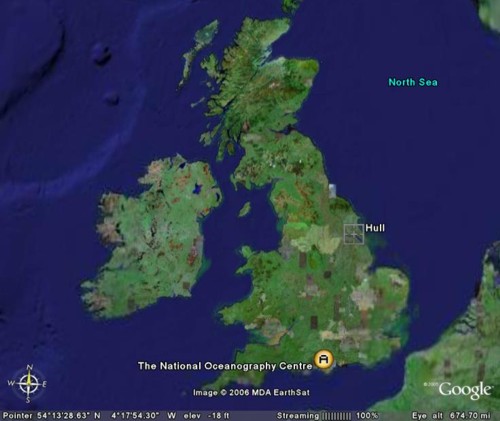
There is something on our dock, however. See the red things at the northwest end? That's our remote operated vehicle(ROV), called ISIS. If you squint, you can see the launch cradle for the ROV and a container containing the control apparatus, which I've highlighted in the magnified image: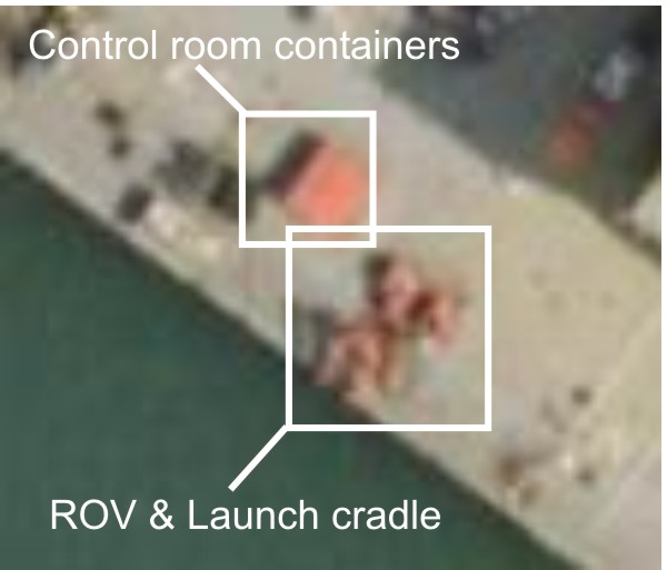
Again, and again unfortunately, is it no accident that the satellite has caught it on the docks, because that is where it has remained since arriving at NOCS in mid-2003. In another instance of stunning foresight, no-one thought to secure funding to do anything with our expensive new toy (which has led some wit to recast the acronym as Is Still In Southampton), so there it sits with nothing to do.
So if you want locational irony, I have it in spades: I'm a geologist based at an oceanography centre, a centre which has a dockside location but rarely sees a research vessel, and an ROV which hasn't touched water for almost three years. And if that's not enough for you, try the fact that although I've been based in the UK, I've spent the last four years studying the tectonics of New Zealand. Fortunately, most days I find this quite funny.
30 January, 2006
Locational irony
![]()
Subscribe to:
Post Comments (Atom)
No comments:
Post a Comment