

The recent tectonic history of Almeria, SE Spain, has produced some varied and interesting geology, a key ingredient of any successful field trip. The region lies within the Cordillera, a mountain range produced as Africa has collided with Europe in the Alpine orogeny. The thrust sheets, or nappes, generated by this collision form the high Sierras. Around Carboneras, where we stayed on our recent excursion, they are made of dark metamorphic rocks – sediments which have been deeply buried, causing the growth of new minerals at higher temperature and pressures, then brought back to the surface (exhumed) by the thrusting. 
This photo also shows two other common sights in the region: vast acres of greenhouses which supply the rest of Europe with their tomatoes, and a forest of cranes building ever more holiday apartments, probably for us Brits.
Following formation of the Betics, the tectonic regime changed from about 10 million years ago, with the initiation of left lateral strike-slip faults (like the San Andreas Fault, but with the opposite sense of movement). Historical records of Almeria and other nearby cities being flattened show that some are still active today – the last recorded big earthquake was in 1865. The Grantilla River cuts across the Carboneras Fault, exposing a ‘neapolitan ice-cream slice’.
Large faults rarely consist of a single narrow fissure in the earth; instead motion occurs along a number of interlinked faults across a broader fault zone. Within these zones fault-bounded ‘slices’ of rocks of different ages and types are all randomly mixed together. This process is perfectly illustrated in this section because all the different rocks have distinctive colours.
This new tectonic activity also included the formation of sedimentary basins, possibly pull-apart basins at bends in the strike-slip faults. The sequence of rocks deposited in these basins records a sequence of increasingly shallow marine environments. This shallowing-up sequence is not only due to sedimentation (if you make a hole it fills up), but also because the Africa-Europe collision has continued to uplift the region, as is obvious from the fact that all of these marine deposits are now above sea level. The very oldest sediments record very deep water environments, punctuated with periodic debris flows, where landslides at the edge of the continental shelf have transferred material into deeper waters. Some of these must have been massive; the next picture shows ‘El Gordo’, a truly stupendous chunk, or megaclast, of deformed sediments within one of these debris flows. 
A few million years later, and the water depths are shallow enough for coral reefs to grow. In most places the corals themselves haven’t preserved too well – they’ve dissolved away, leaving holes marking where they once were.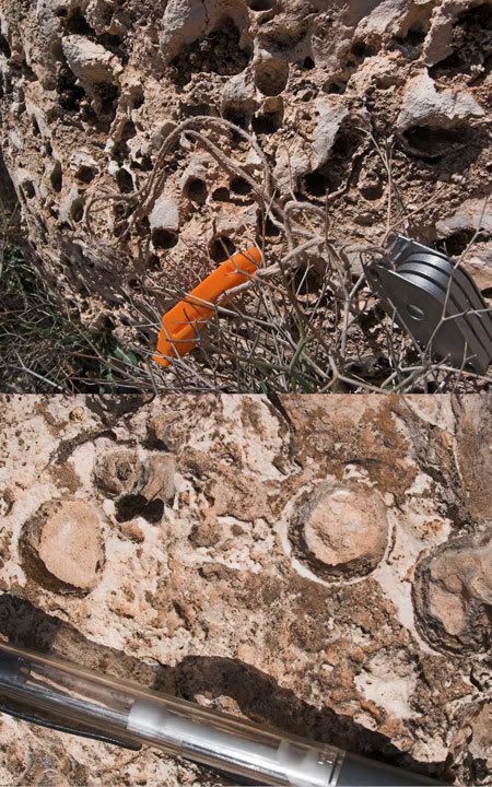
The youngest sediments in these basins preserve a mud-flat environment, complete with preserved raindrop marks.
You can also see dessication cracks and bird footprints (the three-pronged feature on this photo may be one, although I didn’t notice it at the time).
Towards the coast, things are a bit different, with a lot of evidence of volcanic activity. One of the ancient volcanoes in this area is especially interesting, because the lavas contain large garnet crystals.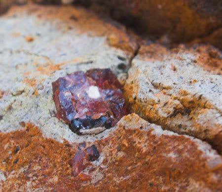
This is odd, because garnets are metamorphic minerals which only form at much greater depths than a typical magma chamber. What seems to have happened is that the volcano has erupted through metamorphic rock, melting it and incorporating the garnets into the magma. There is evidence for this, in the form of xenoliths of garnet-bearing metamorphic rock that have also been incorporated into the volcanics. 
Volcanic activity also caused hot, mineral rich fluids and gases to circulate through the surrounding sediments, producing deposits rich in economically important minerals such as barite, and galena (lead ore). We visited a couple of mines, and even saw some fossil fumaroles, where the gases and fluids were released at the surface (a bit like the black smokers at mid-ocean ridges).
Hopefully these pictures have given you some idea of why we take our students to Almeria – there’s some really cool geology to be seen here. The nice weather, tapas and coffee are mere bonuses…
14 April, 2006
Geological postcards from Almeria
![]()
Subscribe to:
Post Comments (Atom)
2 comments:
Hi Chris, thanks for your postcards from Almeria, May i used them for my work, how can i reference to you? I was searching for geological abstract of the volcanic coast of Almeria like introduction to a paper, please if you have more details would you mind to send them to me?
Please send your answer to mardesur_01@hotmail.com as soon as posible.
Hi Chris, Very interesting! I will certainly have a look out for them when I'm out and about.
Post a Comment